

Hello, everyone.
This is Enta.
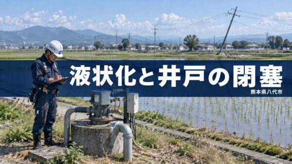
The other day, I went to Yatsushiro City in Kumamoto Prefecture.
It all began with the "Reiwa 8 Kumamoto Earthquake," which occurred on July 28, 2026.
The epicenter was near the Hinagu Fault, and Yatsushiro City recorded a seismic intensity of 6+ on the Japanese seismic intensity scale.
Since the epicenter was closer to Yatsushiro than it was during the Heisei 28 Kumamoto Earthquake 10 years ago (when Yatsushiro City recorded a seismic intensity of 6-), this area experienced both stronger shaking and more severe damage.
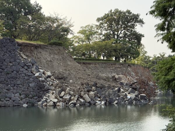
At first glance when I arrived at the scene, it didn't look like the damage was that bad.
However, upon closer inspection, signs of the damage were visible all over the city.
At “Matsuhamaken,” a garden designated as a National Scenic Spot, part of the main house and a storehouse had collapsed, while at Yatsushiro Shrine (Myoken-gu), a Prefectural Important Cultural Property, the gate tower had collapsed and the worship hall was crushed.
Myoken Shrine is the venue for the “Yatsushiro Myoken Festival,” one of Kyushu’s three major festivals and a UNESCO Intangible Cultural Heritage site.
Even if a building looks ordinary at first glance, the fact that historic buildings tend to sustain the most damage is what makes earthquakes so frightening, isn't it?
But that's beside the point.
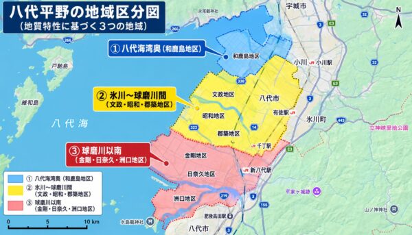
Based on geological data, I have created a map showing the general geographical layout and regional soil classifications around Yatsushiro City.
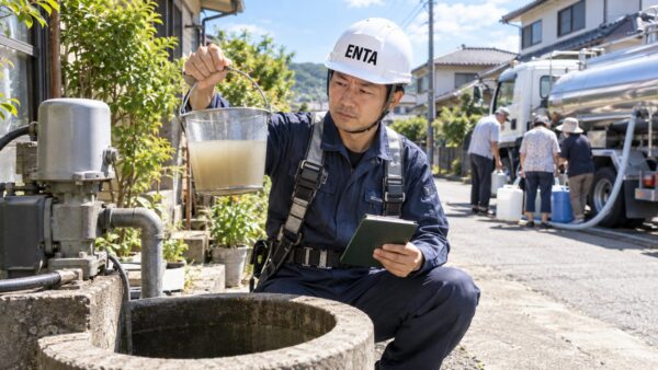
Following instructions from a senior colleague, I decided to conduct a “well survey.”
This is where the main reason I came to Yatsushiro begins.
After receiving instructions from a senior colleague to “figure it out,” I went to inspect the well.
Since it's an order from my senior colleagues, I guess I'll just have to get it done without complaint lol
Yatsushiro City is an area with an abundance of groundwater.
According to Yatsushiro City, of the city’s population of approximately 117,500, just under 60,000 use the municipal water supply, and just under half of the population relies on groundwater (wells) for domestic water.
In particular, the five school districts of Kongo, Ueyanagi, Takada, Mugishima, and Futami are areas that were never originally equipped with a public water supply system and rely almost entirely on groundwater for their daily water needs!!
That well sustained significant damage in the recent earthquake.
According to survey results announced by Yatsushiro City on August 17, approximately 4,400 households in the city have suffered damage to their wells. In the five school districts without a municipal water supply, damage was confirmed in 2,000 households—about 20 percent of the approximately 9,700 households there. Even in areas where both the municipal water supply and wells are used, damage was confirmed in 2,400 households—about 10 percent of the approximately 29,000 households there.
There are only about 15 companies in Kumamoto Prefecture that specialize in well drilling; of those, three are located in Yatsushiro City, and it appears that two of them were on the verge of closing due to an aging workforce, resulting in a significant backlog of repair requests.
In the Kongo district, residents could be seen coming to fill up their containers with water from water trucks.
The person I was with volunteered three times a week to deliver water.
When I hear people say, “The water stopped flowing from the well after the earthquake,” I really feel how painful that must be, especially since this is a region blessed with abundant groundwater.
To begin with, what kind of soil does the Yatsushiro Plain consist of?
Why has damage to wells been so concentrated in Yatsushiro?
To figure this out, I first looked into what kind of soil the Yatsushiro Plain has, lol.
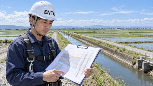
According to a research paper published by the Japan Society of Applied Geology that I found online, the Yatsushiro Plain is an alluvial plain measuring approximately 25 km north to south and 10 km east to west, formed by sediment deposited by three rivers: the Kuma, Suna, and Hikawa. Furthermore, because land reclamation has been carried out there since ancient times, taking advantage of the shallow water depths, it is said that approximately two-thirds of the Yatsushiro Plain today consists of land created through reclamation. Since reclaimed land is essentially created by piling soil onto soft ground, it inherently possesses conditions that make it vulnerable to earthquakes.
Based on the results of borehole surveys along the Yatsushiro coast, the paper divides the Yatsushiro Plain into three regions according to their geological characteristics.
- (1) Inner part of Yatsushiro Bay: Wakashima District
- ② Between the Hikawa and Kuma Rivers: Bunsei, Showa, and Guntsuki Districts
- ③ South of the Kuma River: Kongo, Hinagu, and Suguchi Districts
The table below lists the test results for the sandy soil layer (As1 layer), which is widely distributed near the ground surface.
| Test Items | Wakashima | Bunsei | Showa | Gunchiku | Kongō | Hinaku | Suguchi |
|---|---|---|---|---|---|---|---|
| Moist density ρt (g/cm³) | 1.872 | 1.832 | 1.822 | 1.832 | 1.862 | 1.828 | 1.824 |
| Natural Moisture Content wn (%) | 33.6 | 32.2 | 33.0 | 35.3 | 35.6 | 38.5 | 26.8 |
| Pore ratio e | 0.976 | 0.934 | 1.054 | 1.001 | 0.983 | 1.049 | 1.003 |
| Grain Size and Sand Content (%) | 73.6 | 70.9 | 80.4 | 77.8 | 71.0 | 36.5 | 54.4 |
Source: The Society of Applied Geology, “Geological Characteristics of the Yatsushiro Plain in Kumamoto Prefecture” (Higashi, Kimura, and Udon, Chiyoda Kogyo), Table 1
The paper states that the fine-grain content in the Wakashima–Kongō area ranges from Fc = 17.5 to 25.41 TP3T, and while in the Hinaku–Suguchi area, it is reported to be Fc = 38.0–57.41 TP3T (plasticity index Ip = 11.4–12.4).
Furthermore, the paper clearly states that the As1 layer is “a saturated, loose sand layer that can be considered a soil layer with a high potential for liquefaction.”
In fact, this area coincides exactly with the five school districts (Kongō, Ueyanagi, Takada, Mugishima, and Futami) where the well-related damage was most concentrated this time.
What exactly is liquefaction?
Now, let's review how liquefaction actually works, lol.
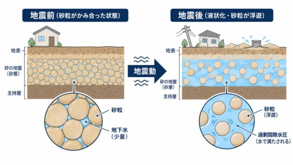
This is a basic concept, but liquefaction is defined as a phenomenon in which, when the ground is subjected to a strong seismic shock, soil particles that were previously in contact with and supporting one another become separated, causing the entire ground to take on a sludgy, liquid-like state. Groundwater is present within the soil, and sand particles resist the surrounding pressure (effective stress) while remaining in contact with one another.
When seismic motion is applied here, the interlocking of the sand grains is temporarily disrupted, causing water to take over the load-bearing role in place of the sand grains.
It is well known that liquefaction can cause damage such as undulating roads, manhole covers popping up, and differential settlement of buildings; however, at the same time, another troublesome phenomenon is occurring beneath the ground. That is the topic of this article: “well blockage.”
Why Do Wells Become Clogged When Liquefaction Occurs?
Based on what I’ve observed on-site and the research I’ve conducted this time, I believe the well blockage occurs in the following sequence.
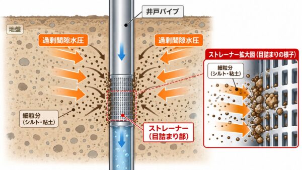
First, when the earthquake’s shaking causes the interlocking of sand grains in the ground to break, the pressure that had previously been supported by the sand grains suddenly bears down on the groundwater, which has nowhere else to go.
This is excess pore water pressure.
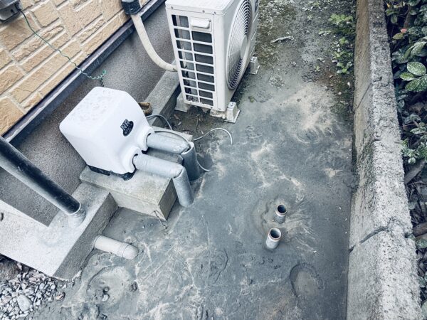
Although the pressure within the ground is naturally quite high, the only pressure inside a well pipe is essentially water pressure.
In other words, excess pore water pressure that has nowhere to go within the ground tends to concentrate toward the well casing, where the pressure is lower.
The FAQ section of the Japan Groundwater Society (a public interest incorporated association) states that, while water outages and turbidity in the municipal water supply are more likely to be issues after a major earthquake than problems with the wells themselves, it also mentions that in areas relying on groundwater as a water source, turbidity and blockages can occur after an earthquake.
It is said that when a well is actually dug and turbidity occurs, sand and sediment stirred up by the disturbance of the soil layers are discharged along with the water; while the water may eventually clear up over time, there are also cases where the turbidity does not subside and the water stops flowing.
In the case of Yatsushiro, it is reasonable to assume that, under the pressure of excess pore water pressure, the fine-grained material (silt and clay) in the soil rushed all at once toward the well’s strainer (water intake section), causing it to become clogged.
In fact, at the site, that pressure was forcing sand into the pump, which ended up destroying it!
In addition, there were many cases where the piping around the wells—such as PVC and SGP pipes—had ruptured due to the violent shaking caused by the earthquake.
If the pipe breaks, the very pathway for the water to flow up is lost, so this is a matter that goes beyond whether or not it gets clogged.
This time, we'll start with a field survey.
To be honest, my work mainly involves slope and ground reinforcement, so I'm not an expert on wells themselves.
That said, I’ve dug plenty of wells so far, lol. If you asked me, “Are you a well driller?” I’d have to say I’m actually a slope engineer…
However, since there are many similarities when it comes to interpreting what’s happening within the ground—and since this was also a directive from a senior colleague—I started by thoroughly inspecting the site.
In areas like the Yatsushiro Plain—which are reclaimed lands and also exhibit regional variations in the percentage of fine particles in the sandy soil—even when the problem is described as a “clogged well,” the priority of countermeasures will vary depending on whether the cause is the influx of fine particles due to excessive pore water pressure or a rupture in the piping itself.
As for the next steps and plans moving forward, I intend to come up with my own ideas while coordinating with local well-drilling contractors and reviewing the findings from the local government’s survey.
See you later.
I'm spending half of the Obon holiday working nonstop on drilling a well for disaster preparedness.