

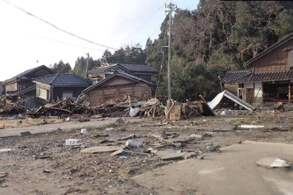
On January 9, the Earthquake Engineering Committee of the Japan Society of Civil Engineers (chaired by Hisakazu Sakai), in collaboration with the Society’s Coastal Engineering Committee, the Japan Society of Earthquake Engineering, and the Japanese Geotechnical Society, held an online briefing session to present the results of surveys on the damage caused by the Noto Peninsula Earthquake, which registered a seismic intensity of 7. Titled “Preliminary Report on the Reiwa 6 Noto Peninsula Earthquake (M7.6),” the session featured reports organized by theme—covering “tsunami,” “buildings,” “ground,” “bridges,” and “castles” (Kanazawa Castle)—based on surveys conducted in the affected areas. The session was moderated by Yusuke Ono (Professor, Tottori University).
At the outset, Chairman Sakai (Professor at Hosei University) stated, “Earthquakes give rise to new lessons. In recent years, Japan has experienced many destructive earthquakes, such as the 1995 Southern Hyogo Prefecture Earthquake, the 2011 Great East Japan Earthquake, and the 2016 Kumamoto Earthquake, and has implemented measures for earthquake prevention and disaster mitigation based on the insights gained from these events. However, despite the measures we have been advancing regarding tsunamis and landslides in response to this earthquake, we have suffered a significant loss of life. Today’s briefing is attended by individuals from various backgrounds. I hope you will provide information that contributes to disaster mitigation and help identify new challenges,” he said in his opening remarks.
In addition, Shigeyoshi Tanaka, President of the Japan Society of Civil Engineers, announced the following policy on the same day: “We have established a Disaster Response Headquarters and are taking measures such as gathering various types of information. We will provide information on the Social Support Division’s website for the purposes of relief and rescue, as well as recovery and reconstruction support.”
There have also been cases of collapse even under the “1981 Standards”
The survey on “building damage” was conducted by Akira Murata (Assistant Professor, Kanazawa University) and Tatsu Suda (Professor, Kanazawa Institute of Technology). The survey covered the following areas: Monzen in Wajima City, downtown Wajima City, Suzu City, Noto Town, Anamizu Town, Nanao City, and Nakanoto Town.
As a general observation from the survey, the impact of killer pulses—slightly shorter tremors with a period of 1 to 2 seconds within the overall seismic cycle—was particularly severe, especially in the Shōin district of Suzu City and Anamizu Town. In the Shōin district of Suzu City, the collapse of shrine and temple structures was particularly pronounced following an earthquake with a 3-second period; it was a significant finding that the effects of structural fatigue caused by the strong earthquake in May 2023 and the swarm of earthquakes prior to that were clearly evident.
The Monzen district of Wajima City was an area that experienced severe shaking during the 2007 Noto Peninsula Earthquake; although a significant number of buildings have been newly constructed or renovated, reports indicate that there were many instances of buildings collapsing due to the earthquake. “The challenge lies in determining the appropriate balance—in terms of the extent of structural reinforcement required and the associated costs—and finding the right compromise. In fact, among buildings that underwent significant structural work during renovation, there are some that stand firmly on their own, so this should be factored into the building assessment,” said Akira Murata.
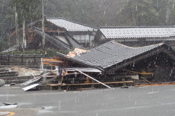
The extent of damage to buildings constructed under the old seismic standards is extremely severe, and many homes believed to have been built under the new seismic standards adopted in 1981 or later have also sustained significant damage. However, much of this damage is thought to have occurred in buildings that underwent additions or renovations after 1981. On the other hand, for buildings constructed after 2000, damage caused by the seismic shaking was minor in almost all cases.
Bridge Abutment Subsidence Leads to Loss of Transportation Infrastructure Functionality
Regarding “bridge damage,” a research team was formed shortly after the earthquake, consisting of Kazuma Inoue (Associate Professor, Gunma National College of Technology), Yoshihiro Uemura (Assistant Professor, Kyoto University), Masataka Shiga (Assistant Professor, Nagaoka University of Technology), and Atsushi Kurima (Assistant Professor, University of Tokyo). The team conducted surveys in Nagaoka City, Niigata Prefecture; Naka Ward and Nishi Ward, Niigata City; Himi City, Toyama Prefecture; and Nanao City, Kanazawa City, Kahoku City, and Uchinada Town, Ishikawa Prefecture.
In a previous study conducted by the National Institute for Land and Infrastructure Management, an analysis of 376 bridges that had been classified as requiring “caution due to road surface unevenness” following the Great East Japan Earthquake revealed that 90 percent of them exhibited deformation in the approach sections at the rear of the abutments. The survey conducted by the current research team revealed a similar trend. Specifically, the rear sections of the abutments have subsided, causing unevenness in the road surface. (See photo.)
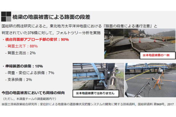
Regarding specific instances of damage, at the “Kamishō River Bridge” in Himi City (completed in 2000), although ground damage was observed at the approach section behind the abutment, no damage to the bridge structure itself was confirmed. However, liquefaction and water leaks caused by damage to water mains occurred in the surrounding ground, resulting in a water outage in the area. At the approach sections of several bridges spanning the Misogi River—including the city’s “Owan Bridge” (completed in 1991)—discontinuities were observed, and minor damage was noted to the bridge abutments and upper portions of the retaining walls on the Owan Bridge. At the Akaura Bridge (completed in 1972) and its surroundings, ground deformation occurred in the surrounding area, and ground damage was observed on the rear side of the abutments. Additionally, although ground damage was observed on the rear side of the abutments at the Notojima Bridge (completed in 1982), no damage to the bridge structure itself was confirmed. At the Saida Ohashi Bridge (completed in 1980) in Kanazawa City, a large step had formed on the northern approach, the bearings were damaged, and the girder had fallen. As a result, the expansion joint had opened significantly. (See photo)
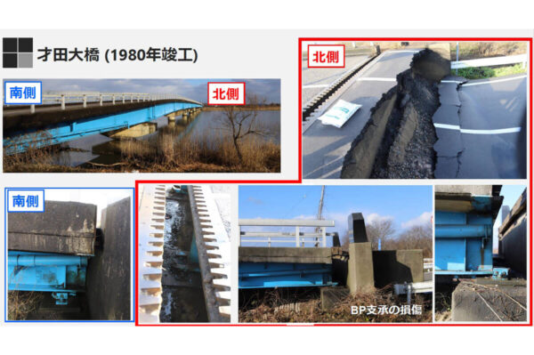
To summarize this study, there were cases where a step formed due to settlement in the approach section at the rear of the abutment. It is highly significant that, even when the bridge structure itself was sound, the presence of this step led to a reduction or loss of its functionality as “transportation infrastructure.”
The Coastal Engineering Committee is investigating flood depths and flood marks
Mr. Masatoshi Yui (Professor at Kanazawa University) of the Japan Society of Civil Engineers’ Coastal Engineering Committee’s “R6 Noto Peninsula Earthquake and Tsunami Investigation Group” reported on the tsunami damage. On January 1, the day the earthquake struck, a group of volunteers from the Coastal Engineering Committee had already begun discussions on the possibility of forming an investigation team. It was decided to establish the “R6 Noto Peninsula Earthquake and Tsunami Investigation Group” within the Coastal Engineering Committee, and a joint team comprising Kanazawa University, Hokuriku Advanced Institute of Technology, Kanazawa Institute of Technology, and Tohoku University was formed as an advance party. They reported on road conditions between Kanazawa and Suzu City, the extent of damage, on-site conditions, and the results of the tsunami survey. Currently, a total of 20 universities and institutions, including those whose surveys are ongoing, have begun their investigations in succession. Although the overall survey area spans Ishikawa, Toyama, and Niigata Prefectures, the report presented at the preliminary briefing focused on three specific areas: Wajima City, Suzu City, and Noto Town.
The survey focused on two items: “flood depth,” which is the depth of flooding measured from the ground, and “mark height,” which is the height of marks relative to a reference plane. These measurements—including mark height, flood depth, and the extent of flooding—were taken using total stations, RTK-GPS, and aerial photography. At the preliminary briefing, it was reported that in the western part of Wajima City, changes in the shoreline due to ground uplift were particularly noticeable north of “Kotogahama,” flooding damage occurred in the “Teraya,” “Iida,” and “Ukai” districts in the eastern and southern parts of Suzu City, and flooding damage occurred in the “Matsunami” and “Nunoura” districts in the northeastern part of Noto Town.
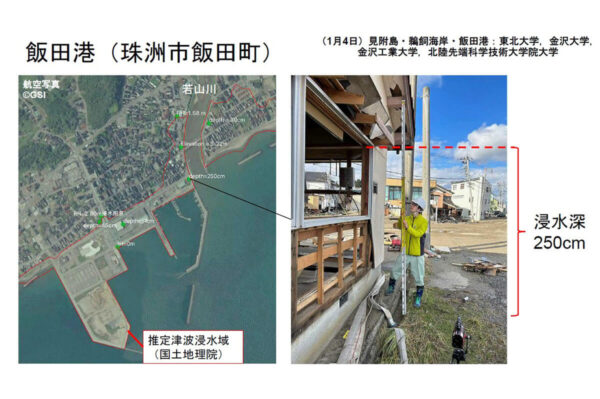
The results of this survey will be provided to relevant organizations as foundational data for assessing the full extent of damage in coastal areas and for future recovery efforts. The Coastal Engineering Committee of the Japan Society of Civil Engineers is scheduled to hold a survey briefing session in Kanazawa City on January 27, and is currently preparing to present a more comprehensive survey report at that time.
Extensive ground damage has been confirmed in the reclaimed land area
For the “Ground Damage” section, the investigation team included Kazuma Inoue (Associate Professor, Gunma National College of Technology), Yoshihiro Uemura (Assistant Professor, Kyoto University), Ryo Tomobe (Assistant Professor, Tokyo Institute of Technology), Masataka Shiga (Assistant Professor, Nagaoka University of Technology), and Jun Kurima (Assistant Professor, University of Tokyo) participated as members of the survey team. Surveys conducted in Niigata City, Niigata Prefecture; Himi City, Toyama Prefecture; Nanao City, Ishikawa Prefecture; and the area surrounding Kakogata Lake confirmed extensive ground damage spanning Niigata, Toyama, and Ishikawa Prefectures. Although Niigata City is located far from the Noto Peninsula, ground subsidence and cracks in the pavement were also observed there.
In the vicinity of Kanazawa, extensive ground damage was confirmed, particularly in reclaimed land areas, and widespread liquefaction occurred along roads facing the Kahokugata Lagoon. Within the reclaimed land areas of Uchinada Town and Kahoku City, liquefaction, road subsidence, and tilting of houses and utility poles were observed. Although there was no damage to the school buildings in the area, cracks and subsidence occurred in the entrance areas and on the school grounds. In central Nanao City, liquefaction occurred in coastal areas and along rivers, and in the city center, some wooden houses collapsed. In particular, traditional earthen-walled storehouses collapsed, blocking roadways. Furthermore, on the hillsides to the southwest of the city center and in the valleys near the castle ruins, some temples and shrines were completely destroyed, while in other areas—such as those located on the ridges of the castle ruins—the roof tiles remained largely undamaged.
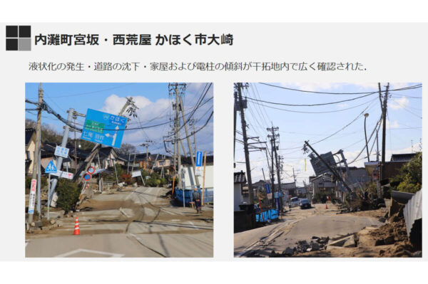
The summary of the survey noted that “ground damage was observed across a wide area ranging from urban to rural areas,” “road subsidence, tilting or collapse of houses and utility poles, liquefaction, and landslides were confirmed,” and “landslides occurred in numerous locations on slopes composed of weathered sandstone.”
Finally, Mr. Keita Abe (Director of the Japan Society of Earthquake Engineering and Associate Professor at Nihon University) spoke about the significance of the briefing session, stating, “I hope that the information shared through the reports and discussions at this briefing session will contribute to future investigations, recovery efforts, and disaster mitigation measures for major earthquakes in the future,” and delivered the closing remarks.